Tropical Storm Pamela became the 16th named storm of the 2021 East Pacific hurricane season when it developed south of Mexico on Sunday evening, and AccuWeather forecasters expect the storm to strengthen into a powerful hurricane this week on its path toward western Mexico.
As of 11 a.m. EDT on Monday, Pamela was located about 455 miles south of Mazatlan, Mexico, and was tracking northwest at 8 mph, the National Hurricane Center said. Hurricane watches and tropical storm watches were issued for parts of Mexico’s southwestern coast on Monday as well as parts of extreme southern Baja California Sur, according to the NHC.
The tropical storm was circulating off the coast of the Mexican states of Jalisco, Colima and Michocán and is forecast to continue its northwestward path along the coast of Mexico. Pamela will likely make a gradual northeastward turn back toward Mexico due to the steering environment.
 |
Pamela is likely to intensify into a hurricane (maximum sustained winds of 74 mph or greater) by late Monday and may become a Category 3 major hurricane (maximum sustained winds of 111 mph) by later Tuesday or Tuesday night. A major hurricane has maximum sustained winds of 111 mph or higher.
“The combination of warm ocean waters and light wind shear will allow Pamela to intensify over the next couple of days,” AccuWeather senior meteorologist Rob Miller said.
AccuWeather meteorologists are forecasting that impacts from Pamela will be felt along the coasts of southern Baja California Sur and Sinaloa as early as Tuesday evening, local time.
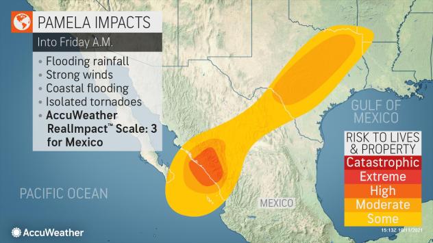 |
Heavy rainfall and damaging wind gusts will accompany what is expected to be Hurricane Pamela as it approaches the coast before then making landfall on Wednesday, said AccuWeather hurricane expert and senior meteorologist Dan Kottlowski.
As Pamela approaches the coast of western Mexico on Wednesday, a few factors will affect the intensity level of the storm.
“Wind shear and interaction with land will likely cause Pamela to lose some wind intensity prior to landfall, but Pamela is expected to remain a Category 3 hurricane (maximum sustained winds of 111-129 mph, or 178-208 km/h) at landfall,” Miller said.
If Pamela maintains Category 3 intensity while making landfall, it will be the second major hurricane of the year to do so in Mexico but the first from the East Pacific basin.
In August, Grace rapidly intensified into a Category 3 storm right before landfall in eastern Mexico after previously journeying through the Caribbean and Gulf of Mexico. Other storms that have made landfall in Mexico this tropical season include Tropical Storm Dolores and hurricanes Nora and Olaf.
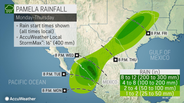
The heaviest rainfall from Pamela is expected to occur across areas of elevated terrain in the Mexican states of Sinaloa and Durango.
 |
“Mudslides are likely to occur along the steeply sloped higher terrain and, when combined with the flash flooding potential, will pose a significant threat to lives and property. Travel will undoubtedly be impacted with major delays likely,” Miller said.
The strongest winds are expected to ravage the Mexican coastline where Pamela moves onshore from Wednesday into Wednesday night. Gusts of 100-120 mph will be possible.
As Pamela tracks inland, a rapid loss of wind intensity is expected as the storm moves over higher terrain. This will cause the Pamala to transition to a tropical rainstorm by Friday.
 |
Pamela could create flooding issues in Texas
Even as the storm becomes less potent, Pamela will remain a concern. Widespread rain will continue across central Mexico and spread into portions of Texas by late week.
“Large portions of both central and eastern Texas are set for a soaking later this week as Pamela crosses through the state, likely as a tropical rainstorm,” AccuWeather meteorologist Mary Gilbert said.
Some locations could record rainfall totals as high as 4-8 inches spanning from central to northeastern Texas into Friday. One major population center forecast to fall in the bull’s-eye of the heaviest rain is the Dallas-Fort Worth metroplex. The Dallas-Fort Worth area has received about 1.35 inches of rain so far in October, or about 31 of the 4.37 inches that is normal for the month, Gilbert said.
This amount of rainfall can lead to significant flooding issues, especially in urban locations or places that have recently been pounded by severe weather.
While the bulk of the growing season is coming to an end across Texas, this upcoming week is still a vulnerable time for one major crop. The process of harvesting cotton is in full swing across portions of the state, AccuWeather senior meteorologist Tyler Roys said.
Texas is the top producer of cotton in the United States with 9,266 square miles of cotton fields across the state as of 2018, according to OneSoil.
“Any heavy rain will hinder the cotton crop as the greatest opportunity to do damage to the crop is at this crucial harvest time,” Roys said.