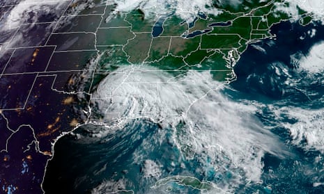
Tropical Storm Cristobal made landfall on Louisiana’s coastline on Sunday 7 June, but the impacts of the storm were felt far and wide. Rainfall rates of 152.4mm an hour were recorded in Florida resulting in flash flooding destroying cars, as well as a tornado forming in downtown Orlando. Prior to landfall on US soil, Cristobal brought destruction along the Gulf of Mexico, with nearly 328.9mm of rain falling in a 24-hour period causing significant flooding, cutting off communities, and triggering landslides. Cristobal is the third named storm of an already busy Atlantic hurricane season.
The start of the monsoon season was officially announced last week in Kerala, India, where favourable conditions for the south-west monsoon have developed. The monsoon season is critical for the agricultural sector, which accounts for approximately 15% India’s economy, playing a vital role in crop irrigation. However, heavy monsoon rains can be hazardous too, bringing the threat of landslides and flash flooding, frequently resulting in the loss of life.
In the central Netherlands, three waterspouts developed over Markermeer Lake, near Lelystad, on Friday. These waterspouts formed as a series of heavy showers passed over the region from the east, these showers later developing into a thunderstorm.

Comments (…)
Sign in or create your Guardian account to join the discussion