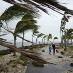
Rain pounded the U.S. Gulf Coast on Sunday ahead of the arrival of Tropical Storm Cristobal, which had already spawned a tornado in Florida.
Roads flooded in coastal Louisiana and Mississippi, and thousands were without power even before the the storm made landfall. It hit U.S. soil late Sunday, though it was not expected to grow into a hurricane.
Forecasters warned the storm would affect a wide area stretching roughly 180 miles (290 kilometers) east into Florida. But they forecast the worst impacts in southeast Louisiana and southern Mississippi, where some spots could get up to 12 inches of rain and storm surges of several feet. Tornadoes were also a danger.
“It’s very efficient, very tropical rainfall,” National Hurricane Center Director Ken Graham said in a Facebook video. “It rains a whole bunch real quick.”
Squalls with tropical-force winds reached the mouth of the Mississippi River by Sunday morning and conditions were expected to deteriorate, the National Hurricane Center in Miami said. Cristobal’s maximum sustained winds remained at 50 mph (85 kph), and it was moving north at 12 mph (19 kph), centered around 75 miles (125 kilometers) south-southwest of the mouth of the Mississippi River.
But the storm already made its presence felt Saturday evening with a tornado that touched down near downtown Orlando, the National Weather Service said. The twister just missed a group of protesters at Lake Eola at around 7:30 p.m. There appeared to be no injuries, but tree limbs were knocked down, and there were reports of power outages.
“Yes, it is related to the tropical storm that is well to our west,” said Scott Kelly, a meteorologist with the National Weather Service in Melbourne, Florida. “But the tropical storm provided a lot of low level shear and that has allowed for some tornadoes to form over Central Florida.”
A tropical storm warning was posted for the northern Gulf of Mexico coast from Intracoastal City, Louisiana, to the Alabama-Florida border. Storm surge warnings and watches were in effect in Louisiana and Mississippi, with flooding up to 5 feet (1.5 meters) expected in some places.
Forecasters said the storm’s center was moving inland across Louisiana late Sunday through early Monday and then would head north across Arkansas and Missouri on Monday afternoon and into Tuesday.
In Louisiana, Gov. John Bel Edwards has declared a state of emergency to prepare for the storm’s possible arrival.
“Now is the time to make your plans, which should include the traditional emergency items along with masks and hand sanitizer as we continue to battle the coronavirus pandemic,” Edwards said in a statement released Thursday.
Jefferson Parish, a suburb of New Orleans, called for voluntary evacuations Saturday of Jean Lafitte, Lower Lafitte, Crown Point and Barataria because of the threat of storm surge, high tides and heavy rain. Residents were urged to move vehicles, boats and campers to higher ground.
“We want to make sure residents are safe as this storm approaches so we are taking all the necessary precautions to be fully prepared,” Jean Lafitte Mayor Tim Kerner Jr. told The Times-Picayune/The New Orleans Advocate.
A similar order was issued Saturday for several Plaquemines Parish communities, including Happy Jack, Grand Bayou, Myrtle Grove, Lake Hertiage, Harlem and Monsecour. The parish’s president, Kirk Lepine, said the order was issued as a precaution.
“We need to ensure residents are protected as this storm draws near, so we are taking all the necessary precautions to be completely prepared,” he said.
Topics Florida Catastrophe Natural Disasters Windstorm Louisiana Flood Mississippi
Was this article valuable?
Here are more articles you may enjoy.


 Survey Shows Majority of Florida, California Homeowners Seeing Higher Insurance Costs
  Investment Funds File New Suits Over Lighthouse Insurance Collapse in 2022
  Allstate Reports $731M in Q1 Pretax Catastrophe Losses
  Uncertainty Keeps Prices Up; No Prior-Year Loss Development: Travelers

