NASA finds Tropical Storm Karen bringing heavy rain to Puerto Rico

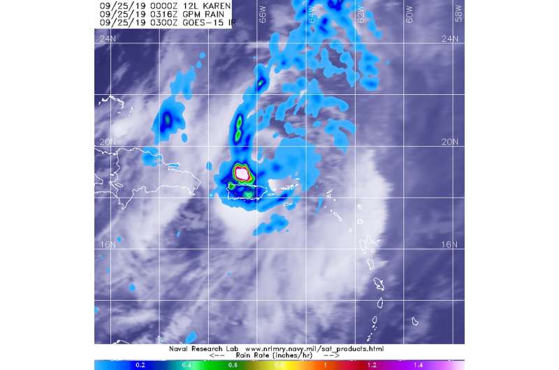
Tropical Storm Karen has crossed over Puerto Rico and into the western Atlantic Ocean. Early on Sept. 25 when Global Precipitation Measurement mission or GPM core satellite passed overhead, the satellite found heavy rain occurring over the territory.
The GPM's core satellite passed over Tropical Storm Karen on Sept. 25 at 0316 UTC (Sept. 24 at 11:16 p.m. EDT). GPM found heavy rain falling at a rate greater than 1.6 inches (40 millimeters) southwest of Karen's center over the Atlantic Ocean and just north of central Puerto Rico. Heavy rain was also falling at more than 1 inch (25 mm) per hour over much of Puerto Rico and extended far to the north of Karen's center into the Atlantic.
Forecasters at NOAA's National Hurricane Center or NHC incorporate the rainfall data into their forecasts. At 11 a.m. EDT (1500 UTC), NHC noted "Karen is expected to produce additional rainfall accumulations of 1 to 2 inches across Puerto Rico and the Virgin Islands, with isolated storm totals of 8 inches."
The center of Tropical Storm Karen was located near latitude 21.7 degrees north and longitude 64.9 degrees west. Karen's center had moved further away from Puerto Rico since the GPM image was collected and was located about 240 miles (385 km) north-northwest of San Juan, Puerto Rico.
Karen was moving toward the north near 15 mph (24 kph). Maximum sustained winds are near 45 mph (75 kph) with higher gusts. Some strengthening is forecast during the next couple of days. Tropical-storm-force winds extend outward up to 70 miles (110 km) from the center. The estimated minimum central pressure is 1003 millibars.
NHC said, "A north-northeastward to northeastward motion with a decrease in forward speed is expected through early Friday. Karen is then expected to slow down and make a clockwise loop over the southwestern Atlantic into the weekend."
Hurricanes are the most powerful weather event on Earth. NASA's expertise in space and scientific exploration contributes to essential services provided to the American people by other federal agencies, such as hurricane weather forecasting.
GPM is a joint mission between NASA and the Japan Aerospace Exploration Agency, JAXA.
More information: For updated forecasts on Karen from NHC, Visit: http://www.nhc.noaa.gov
For local forecasts from the National Weather Service in Puerto Rico, Visit: https://www.weather.gov/sju/
Provided by NASA's Goddard Space Flight Center


