Tropical Depression 16 Forecasted to Become Category 1 Hurricane Within 72 Hours
By Space Coast Daily // October 5, 2017
Residents along the Gulf Coast from Louisiana to Florida should stay alert
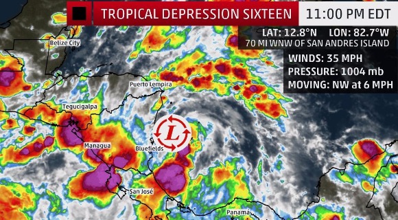
BREVARD COUNTY, FLORIDA— Tropical Depression 16 remains unamed as of the 11 p.m. National Hurricane Center update. However, that is expected to change overnight, as Nate is expected to become the 14th named storm of the Atlantic Hurricane season.
According to the latest NHC update, there have been some structural changes to the depression during the past few hours. Inner-core convection began developing just after the issuance of the previous advisory, and Colombian radar images from San Andres are now showing a well-defined convective band to the east and southeast of the center.
The storm is about 70 miles west-northwest of San Andres Island and about 95 miles south-southeast of Puerto Cabezas, Nicaragua.
Tropical depression 16 is moving northwest at six miles per hour with maximum sustained winds of 35 m.p.h. A Tropical Storm Warning is in effect for Sandy Bay Sirpi, Nicaragua to Punta Castilla, Honduras and a Hurricane Watch is in effect for…
Punta Herrero to Cabo Catoche, Mexico.
The current motion is expected to continue through early Thursday. A north-northwestward motion at a faster forward speed is forecast to begin on Thursday and continue through late Friday. On the forecast track, the center of the depression should move across northeastern Nicaragua and eastern Honduras on Thursday and then over the northwestern Caribbean Sea Thursday night and Friday.
The center is expected to approach the coast of the Yucatan peninsula late Friday. Maximum sustained winds are near 35 mph (55 km/h) with higher gusts. The depression is forecast to strengthen to a tropical storm before it moves inland over northeastern Nicaragua tomorrow.
Additional strengthening is likely over the northwestern Caribbean Sea Thursday night and Friday.

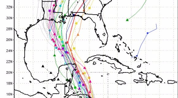

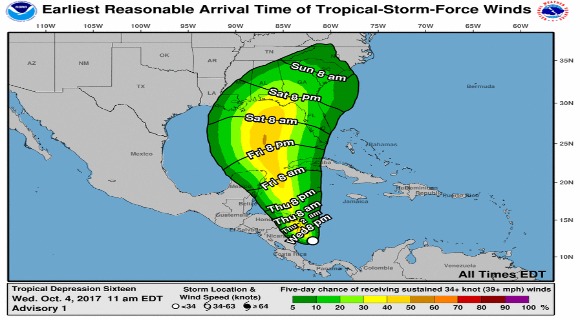
The system is forecast to continue strengthening over the Gulf of Mexico and could affect portions of the northern Gulf Coast as a hurricane this weekend, with direct impacts from wind, storm surge, and heavy rainfall.
However, it is too early to specify the timing, location, or magnitude of these impacts.
Residents along the Gulf Coast from Louisiana to Florida should monitor the progress of this system for the next several days and heed any advice given by local officials.
CLICK HERE FOR BREVARD COUNTY NEWS


